Typhoon Hagupit, locally known as ‘Ruby’ is expected to pound certain areas in the Philippines for three days, as per latest reports from the weather bureau PAGASA. #RubyPH
The Visayas region will particularly feel the intensity of Ruby’s strong winds, heavy rainfall and possible storm surges as it makes landfall starting Saturday night or Sunday morning over the Eastern Samar- Northern Samar area. Its path would cross central Visayas before exiting Mindoro and into Philippine Sea on Monday.

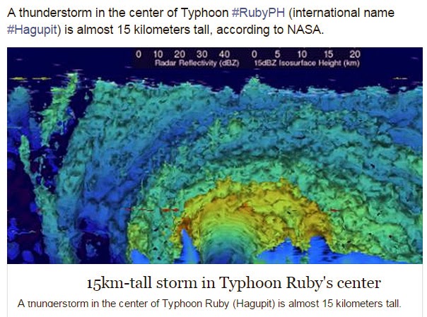
“The GPM satellite flew almost directly above dangerous typhoon Hagupit on December 5, 2014 at 1032 UTC as the typhoon was approaching the Philippines. The GPM Microwave Imager (GMI) instrument measured rain falling at a rate of over 76 mm (almost 3 inches) per hour in the typhoon’s eye wall.
This animated 3-D view of Hagupit’s pred rain falling at a rate of over 76 mm (almost 3 inches) per hour in the typhoon’s eye wall.ecipitation structure was made using data from the Ku band on GPM’s dual frequency radar instrument (DPR). DPR showed that some tall thunderstorm in Hagiput’s eye wall were reaching heights of almost 15 km (about 9.3 miles).” – NASA
Although many felt relieved that the storm has weaken, US weather forecasters assume that the typhoon only underwent an eyewall replacement cycle but strengthened once again after gaining a new eyewall.
UPDATE: Albay state of calamity now

Meanwhile, reports of panic-buying and forced evacuation had been surrounding many areas of Eastern Visayas, the same region that was devastated by super typhoon Haiyan a year ago. President Benigno Aquino has ordered vigilance from all concerned local government unit to prevent or even minimize the impending disasters and threats by the storm.
Netizens, on the other hand, had been circling prayer brigades all-over social medias like Twitter and Facebook for divine intervention against the storm.


